Design of the Seismic Array
Over the course of the OIINK project, we will deploy about 60 state-of-the-art earthquake sensors, or seismometers, in 120 locations spanning an area from southeastern Missouri to western Kentucky. The instruments will be in place for approximately 18 months. During the experiment, the seismographs will record thousands of earthquakes, both within the study area and from around the world, as well as nearby mining and quarry explosions.
Designed like an array of radio telescopes, seismometers will be placed at regular intervals (about every 15 miles) to provide an optimal geometry for imaging the Earth’s interior structure.
Think of it like a telescope directed not at the stars and planets, but at the Earth’s interior.
The seismic stations deployed for this experiment contain digital instruments that are capable of recording every type of ground vibration, from nearby quarry or mine blasts to tiny local earthquakes and larger quakes from around the globe. The ground motion sensors (or “seismometers”) are highly sensitive instruments that turn ground motion into small electrical signals. Those signals, in turn, are amplified and turned into digital signals that are recorded in a small data recorder. Where possible, we will use cell phone technology to transmit data to a central recording site at Indiana University.
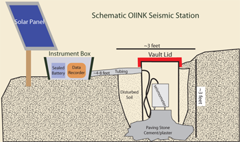
A schematic of an OIINK seismic station is shown in the figure below. Typically, we bury the seismometer on a concrete base in a hole a few feet deep, and install a post for solar panels and a weatherproof box for the electronic recording instruments. A plastic drum is added to protect the seismometer from moisture and dirt, and to insulate the seismometer. This construction, which we term a “field vault,” is capped by insulation and a lid and then buried.
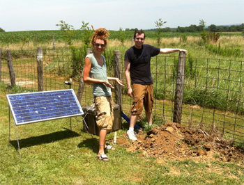
The instrument is powered by batteries and a solar panel. A small GPS receiver is mounted within a few feet of the recording equipment or within the box containing the recording equipment. In a few cases, where the site is in a pasture for grazing animals, we construct a small fence around the site to protect the equipment from damage. This setup is similar to one used successfully on both public and private lands all across the United States.
Site Selection
How do we choose sites? The critical conditions for deploying a seismometer include:
- Sites with a thin layer of well-drained soil over bedrock.
- Sites far enough away from power poles, rivers, roads, houses, or other structures that might produce vibrations.
- Adequate security from vandalism or theft.
- Significant distance from sources of seismic noise such as highways, railways, farm machinery, urban areas, active mines.
- Southern exposure to power our stations using solar panels.
- Adequate road access (generally within a few hundred feet of a road or driveway).
Station Installation - "The Dirty Work"
The equipment will be installed in several stages. First, a reconnaissance team will visit prospective sites and choose the final locations for our 120 seismograph stations. Then a site preparation team will install the equipment. This is the hands-on work of our field effort; these installations typically require a pick and shovel, a container for mixing concrete, and two people to do the work. Access to the site by vehicle at this time is helpful, but not essential.
The second phase involves the actual installation of the electronic equipment that will collect data. This typically involves a two-person crew, installing the seismometer, data recorder, battery and solar panels, and cell-phone modem for data transmission. The instruments are designed to run for months without human intervention.
We expect to visit each site once every few months during the course of the experiment. At the end, we remove the equipment and the field vault. The hole will be refilled and all signs of the installation will be eliminated.
Network Operation - The Array
The OIINK network is deploying in several stages. Beginning in summer 2011, our researchers visited dozens of sites in southern Illinois and southeastern Missouri, selecting sites for the first 60 of the OIINK array stations.
We installed seismic vaults at 38 of the 60 sites. With only a fraction of the network instruments available, we elected to install a pilot network, consisting of 23 seismic stations at sites in a subset of the western half-network.
The pilot network, shown on the map on the following page, together with neighboring sites of the national USArray network (red triangles), are providing us with detailed data on earthquakes and earth structure along the Ozark Dome/Illinois Basin transition.